DRAGSENS 1.30 Details
Shareware 1.48 MB
Publisher Description
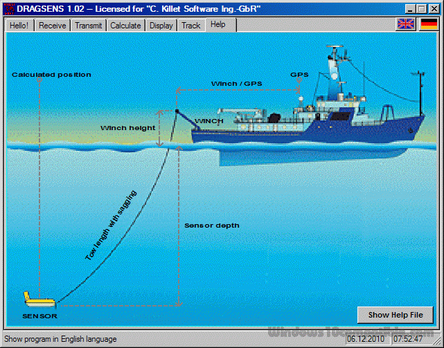
 DRAGSENS Geo Software is used for the exact position estimation of a towed body, sensor, camera, array or net, dragged behind a ship, aircraft or vehicle. The software allows a real-time estimation of the position of a dragged sensor based on the location of a GPS-receiver. The sensor thereby can be dragged underwater, at water or earth surface or be airborne. The software calculates the position of the sensor along the direction opposite to the course by compensation of the drift rate, the rolling and the cornering ability of the towing vehicle. DRAGSENS receives current position data from a standard GPS string (RMC string). From these positions it averages a direction vector. Knowing the length of the tow cable, and the sensor depth, the sensor position is estimated and output in both kilometric and geographic formats. Suitable coefficients help keeping this estimation precise, considering, for example, the cable not as a straight line but as a parabolic arch. DRAGSENS runs under Microsoft Windows and uses two independent serial ports. That also may be USB ports, controlled by a serial port driver. The input port receives the standard position data from the NMEA bus, while the output port gives the sensor position back in both geographic and kilometric format. Several strings with coordinates in different coordinate systems, date / time and additional information are broadcast on the second serial port. They all follow the NMEA standard for the RMC specifications including the checksum bit for transfer controlling. This software at first was developed to add geo tags as an overlay with modern UTM coordinates on the footage taken by a towed underwater video camera. With suitable hardware the program delivers a video image, coming from a towed video camera, with the position as numeric overlay. It will also return the position of any towed sensor, including hydrophones, airguns, sonars or even nets.
Download and use it now: DRAGSENS
Related Programs
Stock Position
Stock Position helps end-user and small organization to manage and follow his inventory. It is required at different locations within a facility or within many locations of a supply network to precede the regular and planned course of production and...
- Freeware
- 01 May 2017
- 2.65 MB
Navigation Icon Set
Navigation Icon Set is a collection of 118 royalty-free stock icons for use in commercial and personal products, including software applications, websites, blogs, and presentations. Icons are carefully created pixel by pixel by the hand of a professional artist. They...
- Demo
- 20 Jul 2015
- 979 KB
Navigation Pane Relief
Navigation Pane Relief is a versatile, flexible, multi-function form for Microsoft Access that can be used to access database objects, such as tables, queries, forms, reports, macros, modules and procedures. Intended as a replacement for the Access 2007 and later...
- Shareware
- 20 Jul 2015
- 1.9 MB
Boat Fishing
How many fish can you catch within 2 minutes? When this game starts, you will be sailing on a boat and carrying a fishing rod and a hook. Use the left and right arrow keys on your keyboard to move...
- Freeware
- 20 Jul 2015
- 260 KB
UTM Coordinate Converter
UTM Coordinate Converter, converts between various geographic coordinate systems, allowing you to convert between various Latitude/Longitudes systems and the Universal Transverse Mercator (UTM) system. It includes a map that displays the location you converter, as well the map allows to...
- Freeware
- 20 Jul 2015
- 61.96 MB